Skip to Content
  • English (US) română
  • Free Returns and Standard Shipping
Geo Log Data
  • 0
    My Cart
  • 0
    Wishlist
  • Sign in
  • Home
  • Geofizica
    • Scanare sol
    • Scanare sol cu dronă
    • Detectie retele subterane
    • Detecție UXO – bombe neexplodate
    • Măsurători georadar (GPR)
    • Electromagnetism – detecții specializate
    • Măsurători magnetice
    • Seismica
    • Măsurători seismice în gaură de foraj
    • Tomografie electrica
    • Măsurători batimetrice (cu dronă)
    • Geofizica pentru arheologie
  • Topografie
    • Masuratori LiDAR cu drona
    • Calcule de volum cu dronă
    • Ortofotoplanuri cu dronă
    • Ridicări topografice
    • Trasări construcții
    • Monitorizare construcții
  • Geofizica Romania
  • Topografie Romania
  • Geofizică si Topografie
    • Geofizică si Topografie pentru infrastructură
    • Geofizică si Topografie pentru energie
    • Geofizică si Topografie pentru construcții civile și industriale
  • Interferometrie satelitară
  • Shop
  • Blog
  • Services
  • Contact us
Geo Log Data
  • 0
  • 0
    • Home
    • Geofizica
      • Scanare sol
      • Scanare sol cu dronă
      • Detectie retele subterane
      • Detecție UXO – bombe neexplodate
      • Măsurători georadar (GPR)
      • Electromagnetism – detecții specializate
      • Măsurători magnetice
      • Seismica
      • Măsurători seismice în gaură de foraj
      • Tomografie electrica
      • Măsurători batimetrice (cu dronă)
      • Geofizica pentru arheologie
    • Topografie
      • Masuratori LiDAR cu drona
      • Calcule de volum cu dronă
      • Ortofotoplanuri cu dronă
      • Ridicări topografice
      • Trasări construcții
      • Monitorizare construcții
    • Geofizica Romania
    • Topografie Romania
    • Geofizică si Topografie
      • Geofizică si Topografie pentru infrastructură
      • Geofizică si Topografie pentru energie
      • Geofizică si Topografie pentru construcții civile și industriale
    • Interferometrie satelitară
    • Shop
    • Blog
    • Services
    • Contact us
  • Free Returns and Standard Shipping
  • English (US) română
  • Sign in

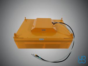
GPR system: Radar Systems Zond Aero 500

Lightweight GPR system, suitable for medium-sized drones like DJI M300 RTK.

Includes a transportation box and mountings for the DJI M300 RTK or DJI M600 Pro drone.

HS Code: 90158020 (meteorological, hydrological, geophysical instrument)

FCC Code: 2AUQQ-ZONDAERO500

IC Code: 25515-ZONDAERO500

Please note that additional components and software must be ordered to use this GPR with drones. It is recommended to order a complete set.


Type Single-channel with shielded antenna Center frequency 500 MHz Operating bandwidth 200-900 MHz (-12 dB) Samples 512 per trace Sample rate 25600 samples/second Scan rate 50 scans/s Sample output 16-bit digital raw data Time range Selectable time range 50, 100, 200 or 300ns Depth Up to 4 meters in average normal soil with 100ns time range Data format Standard Geophysical SEGY Data Format (.sgy) with traces geotagging DOCUMENTATION & DATA SETS Data Sheet
  • Radar Systems Zond Aero 500 GPR Data Sheet »»»
User Manual
  • UgCS SkyHub User Manual »»»
Data Samples
  • Airborne GPR Datasets »»»
ENVIRONMENTAL Temperature -20°C to 60°C internal temperature Humidity 96% non-condensing Ingress protection IP68 in a protective box (used for transportation and for ground surveys) IP52 in airborne variant MECHANICAL Size (L x W x H)
  • 41 x 31 x 16 cm - airborne configuration
  • 52 x 43 x 21 cm - in protective case
  • 71 x 45 x 28 cm – carton box for delivery
Weight
  • 2.1 kg - airborne configuration without mounting kit for the drone
  • 7.1 kg – in protective case
  • 10.0 kg – in cardboard box for delivery
BATTERY Airborne variant DJI M300 RTK or M600/M600 Pro drone main battery is used to provide power to the GPR using standard power socket of the drone intended for payload Ground surveys The battery is integrated into a protective box, operating time up to 12 hours 99 W/h Li-Ion WHAT’S IN THE KIT
  • Zond Aero 500 GPR system with 500 MHz center frequency antenna
  • Prism 2 Data Acquisition/Processing software
  • NANUK protective case (also used for ground surveys)
  • 99 W/h Li-Ion battery integrated into the case (used for ground surveys only)
  • Wi-Fi router integrated into the case (used for ground surveys only)
  • Charger
  • Tow rope for terrestrial surveys
  • Mounting kit to fix GPR system on the DJI M300 RTK or M600/M600 Pro drone


Buy now

How can we help?

Contact us anytime

Call us

+40 724 954 648

Send us a message

office@geologdata.com

Follow us

​ ​ ​

Geo Log Data
  • Home
  • •
  • Termeni și condiții
  • •
  • Livrare și plata
  • •
  • Politica de returnare
  • •
  • Privacy Policy
  • •
  • Help
Copyright © Geo Log Data
English (US) română
Powered by Odoo - The #1 Open Source eCommerce

We use cookies to provide you a better user experience on this website. Cookie Policy

Only essentials I agree